Retail centers and pad sites
Signage and storefront visibility, parking, curb cuts, and the intersection or corridor that drives traffic.
Bluff City Aerial / Commercial real estate photography
Aerial listing photos for retail, office, industrial, and pad sites, edited and sized for LoopNet, Crexi, and your offering memorandum. Flown by a local FAA Part 107 drone pilot.
A ground-level photo shows a storefront. An aerial shows what a buyer or tenant is actually evaluating: the whole building and lot, the parking, how visible the signage is, where the access points are, and the roads and neighbors around it.
Each shoot is planned around the listing. You get 12 to 15 edited stills from the angles that matter for that property, and the same pilot flies every job, so repeat listings keep a consistent look across your portfolio.
A business park building, a retail center, and a downtown property, flown for Memphis brokers.
 3915 MendenhallNAI Saig, business park commercial building
 Shops on Goodman RoadCommand Realty, retail center
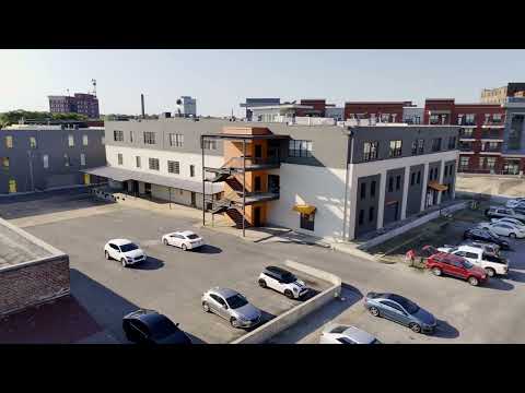 460 Tennessee StreetDowntown Memphis property
Signage and storefront visibility, parking, curb cuts, and the intersection or corridor that drives traffic.
Building overviews, entries, parking fields, and proximity to major roads.
Truck courts, dock doors, trailer parking, yard space, and highway access, shown from above.
Raw land and pad sites read best with the parcel outlined. See land listings with boundary overlays.
Text or email the property address and what the listing needs.
You receive an airspace check, a shot plan, and a fixed price the same day.
Flights are timed for the best light on the building's main frontage.
Edited photos by download link, ready for the listing.
Flights are flown by an FAA Part 107 certified drone pilot and covered by $1 million in liability insurance. Certificates naming the broker or owner as additional insured are available at booking.
Much of Memphis sits in controlled airspace around Memphis International. FAA airspace authorization is requested before any flight that needs it.
12 to 15 edited aerial stills covering the property overview, each side of the building, frontage, access points, and the surrounding area, delivered by download link with a commercial marketing license.
Edited photos are typically delivered within 48 hours of the flight. If you have a listing deadline, include it with your request.
In most cases, yes. Properties in controlled airspace need FAA authorization, which we request before the flight. Some locations close to the airport have lower altitude limits, and the shot plan accounts for that.
Flights are planned to avoid flying directly over people and moving vehicles, following FAA Part 107. Launch points and angles are chosen so busy parking lots and roads are photographed from the side rather than from overhead.
Yes. Parcel boundary overlays with labeled roads and landmarks can be added to any shoot. The outline is a marketing graphic drawn from county parcel data or your survey, not a legal survey.
Every job gets a fixed quote the same day, based on the property and what you need. Call or text 901-497-5656 with the address.
Send the property address and what you need. You'll get a shot plan and a fixed price the same day. Call or text Forrest directly.